Moon and Venus Conjunction: Why Was a Bright “Star” Seen Beside the Moon?

Introduction: The Mystery of a Bright Star

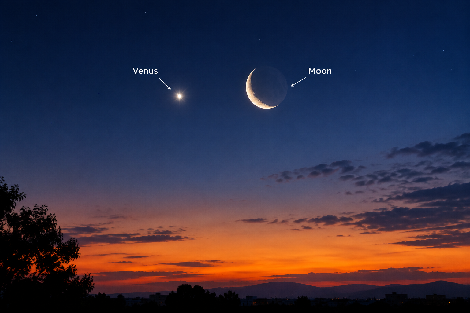
Whenever a bright star appears to shine near the Moon across the vastness of the sky, the curiosity inherent in human nature awakens. What is it? Is it a star that has suddenly appeared? Is it a spacecraft? Or is it a message from the universe? The truth is that this bright “star” is not actually a star at all, but Venus, the brightest planet in our Solar System.

This scene occurs when the Moon and Venus appear close to each other in the sky, an event known in astronomy as a Conjunction. In September 2026, this astonishing sight was visible in many parts of the world, including Pakistan, where the thin crescent Moon and shining Venus appeared together in the evening sky. This article provides a complete explanation of this astronomical event — what it was, why it happened, why Venus appears so bright, and what astronomical principles lie behind it.

What Is a Conjunction? Astronomical Definition and Principles

A conjunction is an astronomical term used when two celestial objects appear close to each other in the sky as viewed from Earth. This “closeness” is actually an optical illusion — these objects may truly be millions or hundreds of millions of miles apart in space, but from the perspective of an observer on Earth, they appear to lie along the same line of sight.

According to NASA’s Goddard Glossary, a conjunction occurs when two or more celestial objects appear close to each other when viewed from Earth. These objects can be two planets, a planet and the Moon, or even a planet and a star. Although these events have very little astronomical significance, they provide extremely beautiful sights to observe.

One important type of conjunction is a Venus conjunction, which occurs between the Moon and Venus. Since the Moon completes one cycle across the sky every 29 days, it passes near one planet or another almost every month. When it passes near Venus, it is called a “Venus conjunction” or a “Moon-Venus conjunction.”

Venus: The Planet That Shines Like a Star

Venus is the second planet from the Sun and, after Earth, is the closest neighboring planet in the Solar System. Its most prominent characteristic is its extraordinary brightness — it is the second-brightest natural object in the night sky after the Moon. Venus is so bright that it can even be seen in daylight, and if the sky is clear, it can even cast shadows.

Why is Venus so bright? There are three basic reasons:

First reason — Thick clouds: Venus has a thick layer of sulfuric acid clouds over its surface that reflects approximately 70 percent of sunlight back into space. This reflective property makes it resemble a mirror.

Second reason — Proximity: Venus is the closest planet to Earth. Its average distance is approximately 41 million kilometers, which is much less than the closest distance of Mars.

Third reason — Size: The diameter of Venus is approximately equal to the diameter of Earth, making it a large and prominent target.

Because of these characteristics, ancient civilizations called Venus the “Morning Star” or the “Evening Star.” When it rises in the east in the morning, it is called the “Morning Star”, and when it sets in the west in the evening, it is called the “Evening Star.” Ancient people believed that the morning star and the evening star were two separate celestial bodies, but Pythagoras proved five hundred years before Christ that they were the same planet.

The September 2026 Event: A Rare Astronomical Sight

On September 14, 2026, an unusual astronomical sight was observed in many parts of the world. On that day, a thin crescent Moon and the planet Venus came extremely close to each other in the sky.

A photographer named Adeel Shafique captured an image of this scene from the city of Lahore, Pakistan, at 6:30 in the evening, showing the delicate crescent Moon and the small crescent of Venus shining together in the sky. He noted that from Lahore it was a “beautiful close conjunction,” because earlier that day, in parts of Asia and Europe, it was a complete Occultation — meaning that the Moon was passing in front of Venus and covering it for a few moments.

The Jordan Astronomical Society also documented this event. According to its president, Ammar Sakaji, Venus began disappearing behind the Moon at 12:47 p.m., completely disappeared at 12:49 p.m., and began reappearing at 2:13 p.m. The total duration of the occultation was approximately one hour and 24 minutes. Both objects appeared in crescent form during this time.

The event was also observed in Saudi Arabia during daylight. From the Noor Astronomical Observatory in the Qassim Region, the occultation continued from 1:04 p.m. to 2:38 p.m. Astronomers warned that special caution was necessary when observing this event during daylight, and pointing a telescope or camera toward the Sun could be extremely dangerous.

The scene was also observed in Bahrain, where the Moon and Venus both shone together in their crescent forms in the western evening sky. On this occasion, the angular distance between the Moon and Venus was only 0.6 degrees, which is extremely close.

Venus as a Crescent: An Interesting Astronomical Fact

One of the most interesting aspects of this event was that not only the Moon but Venus was also appearing in a crescent shape.

How is this possible? The crescent shape of Venus is a result of the fact that this planet orbits the Sun inside Earth’s orbit. Just as the Moon’s orbit causes us to see different portions of it illuminated, Venus also has “phases.” When Venus is between the Sun and Earth, most of its illuminated portion is hidden from us, and we see only a thin crescent.

According to astronomers, Venus is near its maximum brightness when it is in a crescent phase rather than when it is fully illuminated. This is because when Venus is in a crescent phase, it is closer to Earth, and its proximity overcomes the effect of its smaller illuminated portion on its brightness. In contrast, when Venus is fully illuminated, it is on the opposite side of the Sun and much farther from Earth, so its brightness is relatively lower.

Scientific Significance of Conjunctions

Conjunction events are not very important from an astronomical perspective, but they are useful to scientists for several reasons.

Verification of astronomical calculations: As the president of the Jordan Astronomical Society noted, accurate observations of such events help astronomers test their theoretical calculations against real-world data. When an occultation occurs at a previously predicted time, it provides evidence of the accuracy of astronomical models.

Observation of Venus’s surface: Observing Venus through a telescope provides information about its surface. Because of Venus’s thick clouds, it is difficult to see its surface, but by observing its crescent shape and phases, scientists can learn more about its orbit and atmosphere.

Public interest: These events are an effective way to generate public interest in astronomy. When people see a bright star near the Moon in the sky, they want to know what it is, and in this way their understanding of astronomy grows.

Historical Background: Conjunctions and Human Civilization

The meeting of the Moon and Venus in the sky has always held special significance in human history. Ancient civilizations associated Venus with various deities — in Babylon it was regarded as Ishtar (the goddess of love and war), in Greece it was called Aphrodite (the goddess of love), and in Rome it was called Venus.

Venus is also mentioned in Islamic tradition. It was called “Najmah” or “Zuhra,” and ancient Arab astronomers preserved their observations of it in their writings.

The conjunction of the Moon and Venus has been regarded as a good sign in many cultures, while in some traditions it has also been viewed as a prediction of a particular event. Scientifically, it is merely a visual coincidence, but culturally and historically, it has remained an important symbol.

Common Misconceptions and Their Explanation

There are several common misconceptions about the bright star shining near the Moon:

“It is a star”: This is the most common misconception. Venus is a planet, not a star. Stars produce their own light, whereas planets reflect sunlight. The light of Venus is steady and it does not twinkle, while stars appear to twinkle because of the effects of Earth’s atmosphere.

“They have come close to each other”: The Moon and Venus do not actually come close to each other in space. The Moon is approximately 384,000 kilometers from Earth, while Venus’s minimum distance is approximately 40 million kilometers. This means Venus is one hundred times farther away from the Moon. Their closeness in the sky is merely an optical illusion caused by the viewing angle from Earth.

“It is rare”: Although close conjunctions between the Moon and Venus occur every month, their visibility varies. In some months they occur during the day, and in others at night. Therefore, they are not equally prominent every month. An occultation (when the Moon covers Venus) is relatively rare — in Jordan, the next daytime-visible occultation will not occur until 2032.

Conclusion: A Beautiful Glimpse of the Universe

The “bright star” shining near the Moon is actually Venus, the most beautiful and brightest planet in our Solar System. This sight reminds us that we live in a part of the universe where celestial bodies are constantly in motion and continuously change their positions over time.

These conjunction events are not merely a visual spectacle, but they also provide us with an opportunity to understand the system of the universe and its laws. When we look toward the sky and see Venus shining near the Moon, we are actually observing a system that has been orbiting for billions of years.

The beauty of this scene lies in its simplicity — a small crescent Moon and a shining point beside it, which is actually an entire planet, a world about which we still know very little. And perhaps this is its greatest lesson: the universe is still an open book for us, and every conjunction marks the beginning of a new page in it.

The Unsolved Mystery of the Bermuda Triangle

Introduction: The Ocean Region That Captivated the World

Spanning a vast triangular expanse of the Atlantic Ocean bounded by Miami, Bermuda, and San Juan, Puerto Rico, the Bermuda Triangle has captivated the popular imagination for decades. Coined in 1964 by writer Vincent Gaddis in a pulp magazine article, the name quickly became synonymous with mysterious disappearances of aircraft, surface vessels, and mariners without a trace.
Popular lore attributes dozens of unrecovered shipwrecks and aviation losses in the region to paranormal forces, extraterrestrial abductions, or ancient subterranean energy sources. However, rigorous maritime investigations, historical research, and oceanographic data offer far more grounded explanations. This analysis explores the iconic historical incidents, scientific mechanisms, and statistical realities behind the legendary region.


Historic Disappearances and High-Profile Incidents

Flight 19 (1945)

The core incident that popularized the Bermuda Triangle myth occurred on December 5, 1945, when Flight 19—a flight of five U.S. Navy TBM Avenger torpedo bombers—embarked on a routine navigation training mission out of Naval Air Station Fort Lauderdale, Florida. Led by Lieutenant Charles C. Taylor, the flight encountered severe weather and compass malfunctions over the Bahamas.

Radio transcripts reveal that Taylor became disoriented, mistakenly believing he was over the Florida Keys rather than the Bahamas, and directed the flight further out into the open Atlantic until their fuel was completely exhausted. Subsequent Navy investigation reports concluded that spatial disorientation and human error led to a forced water ditching in rough seas. A PBM Mariner search aircraft sent to locate the flight suffered a mid-air explosion, a known operational hazard of the fuel-laden Mariner design, resulting in the loss of 13 additional crew members.

USS Cyclops (1918) and Carroll A. Deering (1921)

Prior to Flight 19, earlier maritime losses contributed to the area’s reputation. In March 1918, the navy collier USS Cyclops disappeared en route from Brazil to Baltimore with 309 crew members and passengers aboard. Carrying a heavy cargo of manganese ore, the ship vanished without sending a distress signal during a stormy passage, likely succumbing to structural failure or a sudden roll in heavy seas.

Similarly, in 1921, the five-masted schooner Carroll A. Deering was found stranded and abandoned on Diamond Shoals off Cape Hatteras, North Carolina. The crew had completely vanished, leaving the ship’s log and navigational equipment missing—an incident historically linked to piracy, mutiny, or hurricane abandonment rather than supernatural phenomena.


Plausible Scientific Explanations

Modern oceanographers, meteorologists, and aviation safety experts attribute disappearances in the region to a combination of environmental and physical factors:

  • Sudden Weather and Gulf Stream Dynamics: The Gulf Stream acts as a powerful ocean river flowing through the region, capable of quickly carrying away wreckage and debris. Severe localized storms, microbursts, and sudden waterspouts develop rapidly over warm tropical waters, creating hazardous conditions for mariners and aviators.
  • Compass Inaccuracy and Magnetic Variation: The Bermuda Triangle is one of the places on Earth where true geographical north and magnetic north align without requiring declination adjustments. Unfamiliar navigators failing to account for local variation can easily veer off course.
  • Methane Hydrate Releases: Methane gas trapped in ocean floor sediments can occasionally bubble up rapidly, significantly decreasing water density and reducing ship buoyancy, leading to sudden sinkings without warning.
  • Rogue Waves: Complex wave intersections off the Atlantic coast can form massive, 30-meter (100-foot) rogue waves capable of overpowering large vessels in minutes.

Statistical Reality and Official Consensus

Despite the persistent myths, formal statistics from major maritime insurance organizations (such as Lloyd’s of London), the U.S. Coast Guard, and the National Oceanic and Atmospheric Administration (NOAA) confirm that the rate of disappearances in the Bermuda Triangle is no higher than in any other heavily traveled ocean route across the globe.

Given the heavy volume of commercial shipping, private boating, and international flights passing through the Florida straits daily, the proportion of accidents remains statistically normal. Neither the U.S. Navy nor international marine underwriters recognize the Bermuda Triangle as a hazardous zone requiring special operational protocols or elevated insurance premiums.


Conclusion: Deconstructing the Myth

The Bermuda Triangle stands as a classic example of sensationalized media storytelling and selective reporting. While early writers synthesized disparate maritime disasters into a singular paranormal narrative, modern scientific research and historical documentation demonstrate that human error, sudden weather events, and natural oceanographic processes account for the region’s historical accidents.

Ultimately, the true mystery of the Bermuda Triangle lies not in any hidden physical anomaly, but in the enduring human desire to find supernatural explanations for the raw, unyielding power of the ocean.

The Enigma of the Ancient Egyptian Pyramids

Introduction: The Last Surviving Wonder

Approximately 4,500 years ago—while Stonehenge was still being erected in Britain and much of the global population lived in Stone Age conditions—an extraordinary engineering achievement unfolded in the Egyptian desert. Centuries passed, the Roman Empire rose and fell, the Industrial Revolution transformed civilization, and humanity set foot on the Moon. Yet, standing today on the Giza Plateau, those same pyramids endure: silent, majestic, and immortal observers of human history.

As the sole surviving entry among the Seven Wonders of the Ancient World, the Great Pyramids represent both an unparalleled architectural triumph and an enduring historical puzzle. While modern research has dramatically expanded our understanding of these ancient monuments, every breakthrough continues to raise compelling new questions. This article provides a comprehensive overview of the mysteries surrounding the Egyptian pyramids—their construction techniques, their intended purposes, and the latest subterranean discoveries revealed by modern science.


How Were the Pyramids Built? The Mysteries of Ancient Engineering

The central question surrounding the Pyramids of Giza is how ancient builders managed to quarry, transport, and stack roughly 2.3 million stone blocks—weighing an average of 2.5 tons each, with some reaching up to 70 tons—into a structure standing 146 meters tall. This monumental task has challenged engineers and architects across generations.

The Traditional Theory: External Earthen Ramps

For decades, orthodox Egyptology proposed that the builders constructed massive ramps made of mudbrick, limestone dust, and rubble to haul the blocks up as the pyramid rose. However, this hypothesis faces critical structural and logistical limitations:

  • Physical Limitations: Pulling massive stone blocks up an incline requires overcoming both gravity and friction. To maintain a manageable incline angle (around 5.7 degrees), a straight ramp would need to extend nearly 1.5 kilometers, requiring a volume of material larger than the pyramid itself.
  • Spatial Constraints: The topography of the Giza Plateau lacks the physical space required for such colossal external ramps.
  • Lack of Archaeological Evidence: Excavations have revealed no remnants of the massive earthen debris that such giant ramp systems would have left behind.

Innovative Models: Modular Counterweight Crane Systems

Recent engineering analyses propose an innovative alternative model that addresses the shortcomings of traditional ramps. Researchers suggest that ancient Egyptians utilized a system of modular, wooden lifting devices arrangeable along vertical lanes on the pyramid’s stepped tiers.

Operating on fundamental principles of counterweights, leverage, and mechanical advantage, these lifting rigs employed wooden beams, heavy ropes, and counterbalancing stones to raise blocks vertically tier by tier. This model offers several compelling advantages:

  • It relies exclusively on verified materials available in ancient Egypt: timber, hemp ropes, limestone weights, and copper tools.
  • Multiple parallel lifting lanes (up to 24 operational lines) could work simultaneously, making the placement rate of 200–250 blocks per day mathematically achievable.
  • It provides a functional explanation for mysterious artifacts found at historical sites, such as quarter-circle wooden rockers and proto-pulley apparatuses. Modern engineering reconstructions have demonstrated that small teams using these simple mechanisms can easily hoist multi-ton blocks several meters in seconds.

These findings reinforce the conclusion that extraordinary alien technology or mythical forces were never required: the pyramids were the product of brilliant human intelligence, rigorous organizational logistics, and refined mechanical engineering principles.


Uncovering Hidden Spaces: Breakthroughs in Non-Invasive Technology

While the construction methods remain a fascinating topic, discovering what lies hidden inside these stone monuments presents an equally thrilling frontier. Modern non-invasive imaging techniques now allow scientists to peer through solid rock without altering the ancient structures.

Muon Tomography: Imaging with Cosmic Rays

In 2017, the international ScanPyramids project achieved a major breakthrough by confirming a massive hidden space—dubbed the “Big Void”—located above the Grand Gallery inside the Great Pyramid of Khufu. This discovery was made using muon radiography, a technique that tracks elementary particles generated when cosmic rays hit Earth’s upper atmosphere.

Because muons pass easily through stone but scatter differently depending on material density, detectors placed inside and around the pyramid mapped the interior structure. The data revealed a void at least 30 meters long, marking the first major structural discovery inside the Great Pyramid since the 19th century.

Recent Cavity Discoveries in the Pyramid of Menkaure

Advanced non-destructive survey methodologies have continued to yield extraordinary insights. High-resolution non-invasive testing—combining Ground-Penetrating Radar (GPR), electrical resistivity tomography, and ultrasound—identified previously unknown chambers and anomalous voids behind the polished granite casing on the eastern facade of the Pyramid of Menkaure (the smallest of the three main Giza pyramids).

The identification of these subsurface cavities supports long-standing hypotheses that the internal architecture of Menkaure’s pyramid features secondary corridors or unexcavated functional chambers, demonstrating that Giza’s monuments still contain unexplored spaces.


Purpose and Symbolism: Monumental Tombs vs. Alternative Claims

Religious Cosmology: Staggered Architecture to the Stars

In mainstream Egyptology, the pyramids were not merely mausoleums; they served as profound theological and cosmic monuments. According to the Pyramid Texts of the Old Kingdom, the stepped and sloped sides of the pyramid represented frozen rays of the sun, serving as a monumental staircase for the deceased Pharaoh’s soul to ascend into the heavens and join the imperishable stars.

Furthermore, the astronomical alignment of the Giza complex reflects deliberate solar geometry. On the summer solstice, an observer positioned at the Sphinx sees the sun set precisely between the silhouettes of the Pyramids of Khufu and Khafre, forming the sacred hieroglyph Akhet (representing the horizon). The entire complex was engineered as a harmonious ritual landscape linking the terrestrial realm with the heavens.

Alternative Hypotheses: Electromagnetic and Underground Networks

In contrast to the consensus among Egyptologists, alternative researchers have proposed technological hypotheses, suggesting the Great Pyramid functioned as a acoustic resonance chamber or piezoelectric energy generator capable of harvesting seismic vibrations.

Subsequent satellite radar studies and subsurface surveys conducted by independent international teams have reported extensive anomalies and potential limestone cavern systems beneath the Giza Plateau at considerable depths. However, geologists point out that the underlying Mokattam limestone formation naturally features vast networks of natural karst caves, sinkholes, and solution channels. Without direct archaeological excavation, claims of artificial underground complexes remain unverified hypotheses.


The Search for the Lost Tombs and Future Excavations

The quest to locate the definitive burial sites and intact royal treasures of the Old Kingdom pharaohs remains active. Modern field projects utilize non-invasive geophysical mapping around the periphery of the Giza Plateau, searching for unrecorded shafts, subterranean corridors, and sealings that may lead to undisturbed royal tomb complexes similar to the discovery of Tutankhamun’s tomb in the Valley of the Kings.

With Egypt’s Supreme Council of Antiquities supervising non-destructive field surveys, the combination of sub-surface radar imaging and targeted remote-operated micro-cameras promises to answer centuries-old questions regarding the precise locations of royal burials without damaging the structural integrity of these world heritage sites.


Conclusion: An Enduring Monument to Human Curiosity

The Pyramids of Giza remain a captivating, open chapter in the book of human history. Each advancement in modern technology—from cosmic ray detectors to advanced computer modeling—gives us a clearer view of these ancient structures while revealing deeper layers of complexity.

Whether viewed as supreme achievements of ancient engineering, profound symbols of solar theology, or enduring mysteries waiting to be fully deciphered, the pyramids continue to inspire awe. Their greatest legacy is perhaps the way they challenge our understanding of the past, compelling us to continuously push the boundaries of science and exploration in search of answers.

Voynich Manuscript: History’s Unbroken Code

Introduction: The Book No One Can Read

Housed within the Beinecke Rare Book and Manuscript Library at Yale University sits an unassuming 240-page parchment codex filled with mysterious illustrations, unknown botanical drawings, intricate cosmological diagrams, and thousands of lines of an undeciphered script. Known worldwide as the Voynich Manuscript, it represents history’s most famously intractable cryptographic puzzle. It is not merely an antique volume; it is an intellectual wall that has confounded generations of linguists, medievalists, mathematicians, professional military codebreakers, and computer scientists for centuries.
The manuscript entered modern historical consciousness in 1912 when Polish antiquarian book dealer Wilfrid Voynich acquired it from a Jesuit college at the Villa Mondragone in Italy. Radiocarbon dating conducted by the University of Arizona systematically determined that the vellum pages were created in the early 15th century, specifically between 1404 and 1438. Yet, despite physical authentication confirming its late medieval provenance, the author’s identity, the purpose of the work, and the underlying linguistic system or cipher remain totally unresolved.


Codicology and Structural Layout of the Manuscript

Physical and paleographic analysis reveals that the Voynich Manuscript was constructed with meticulous care, displaying a clear internal layout despite its unintelligible text:

  • Character Set and Script: The text is composed of an alphabet consisting of 20 to 25 distinct glyphs or characters, written in a smooth, fluid hand from left to right. The script exhibits no visible corrections or erased mistakes, suggesting the scribe wrote with exceptional fluency in the chosen cipher or language.
  • Illustrative Categorization: Based on the subject matter of the colored drawings, scholars traditionally divide the manuscript into five primary thematic sections:
    1. Herbal: Depictions of strange, often unidentifiable plants, root systems, and leaves, accompanying structured blocks of explanatory text.
    2. Astronomical and Astrological: Fold-out diagrams featuring circular charts, suns, moons, and zodiacal symbols accompanied by miniature figures.
    3. Balneological/Biological: Drawings of nude female figures bathing in interconnected pools and intricate networks of green tubes or fluid conduits.
    4. Cosmological: Circular diagrams depicting complex geometric networks, maps, or cosmic structures.
    5. Pharmaceutical: Detailed drawings of plant parts (roots, leaves) next to apothecary jars or vessels, followed by short, recipe-like paragraphs.
  • Textual Organization: The overall structure mirrors classical medieval scientific or medical compendiums. Paragraphs are neatly formatted with regular margins, decorated initials, and structured line breaks that mimic natural human syntax and grammar.

Cryptanalytic Challenges: Why Has the Code Resist Decipherment?

The failure of modern cryptanalysis to decode the Voynich Manuscript stems from several unique structural properties:

  • Absence of Linguistic Relatives: The script lacks clear phonetic or structural equivalence to any known spoken or written human language. Character combinations do not cleanly align with Latin, Greek, Hebrew, or medieval European vernaculars.
  • Possibility of a Constructed Language: Some researchers hypothesize that the text represents an artificial or synthetic language (an early a priori language) created by a medieval scholar to record secret knowledge, lacking natural linguistic evolution.
  • The Hoax Theory versus Structural Consistency: Skeptics have long argued that the manuscript is a 15th-century forgery created to sell to medieval royals for profit. However, statistical analysis reveals that the text exhibits Zipf’s Law—a mathematical property characteristic of natural languages regarding word frequency distribution—making a simple random nonsense forgery highly improbable.
  • Complex Polyalphabetic Ciphers: If encoded, the text likely utilizes multi-layered substitution ciphers, arbitrary abbreviations, or steganographic transposition techniques that disrupt traditional frequency analysis.

Modern Analytical Perspectives: Artificial Intelligence and Statistical Linguistics

Computational Linguistics and Information Entropy

In recent years, researchers have applied advanced natural language processing (NLP) and machine learning models to analyze the manuscript’s underlying structure. Computational studies measuring Information Entropy (the measure of randomness or predictability in text) show that the Voynich script possesses entropy rates nearly identical to natural languages like English, Latin, or Mandarin, proving that the word patterns are highly organized and carry real structural information rather than arbitrary character strings.

Statistical Correlations with Ancient Languages

Quantitative analyses comparing character repetition and word length distributions have shown statistical correlations between “Voynichese” and monosyllabic or tonal languages, including East Asian and Uto-Aztecan dialects, as well as medieval Hebrew shorthand. However, translating these statistical correlations into a coherent, readable text remains an elusive challenge.


Prominent Interpretive Theories

  • Theory 1: An Esoteric Medieval Medical or Herbal Codex: The most widely supported historical theory posits that the book is a confidential medical or pharmacological manual detailing botanical remedies, women’s health practices, and alchemical preparations encoded to protect proprietary medical knowledge from religious persecution or rival practitioners.
  • Theory 2: An Extinct or Unwritten Vernacular: Some linguists argue the text preserves a rare, unwritten regional dialect or an isolated language from Eastern Europe, the Caucasus, or Asia, transcribed phonetically into a custom-designed alphabet.
  • Theory 3: An Advanced Cipher System: Crypto-historians suggest the text was created using a sophisticated substitution system utilizing a cipher wheel or grid matrix, where single words in the original language were converted into multi-character “words” in the manuscript.
  • Theory 4: An Elaborate Historical Hoax: A persistent minority view maintains that a clever renaissance artisan created the manuscript as a high-value curiosity using random character generation tricks, though its linguistic consistency makes this theory difficult to prove entirely.

Conclusion: The Enduring Legacy of the Voynich Manuscript

The Voynich Manuscript remains one of the greatest unsolved mysteries in human history. For over six centuries, its pages have guarded their secrets against the combined efforts of medieval scholars, Renaissance alchemists, World War II codebreakers, and modern supercomputers.

Whether it eventually proves to be a lost medical treatise, an elaborate cryptographic exercise, or a window into an unknown cultural language, the manuscript continues to serve as a profound reminder of the limits of human knowledge and the enduring fascination of the unsolved.

The Strange Legend of the Oak Island Money Pit

Introduction: A Two-Century Quest for a Legendary Treasure

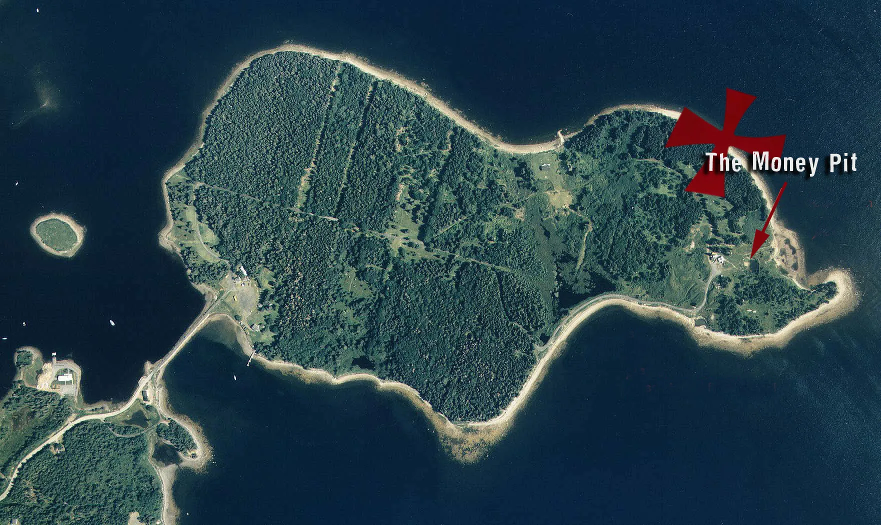
Situated off the coast of Nova Scotia, Canada, a small landmass known as Oak Island has captivated the imaginations of treasure hunters, historians, and researchers for more than two centuries. At the center of this enduring intrigue is a mysterious subterranean excavation known as the “Money Pit”—a complex, deeply engineered shaft rumored to conceal vast historic wealth that has eluded recovery efforts despite relentless exploration.
The saga began in the summer of 1795, when a local youth named Daniel McGinnis discovered a notable depression in the ground beneath the limb of a large oak tree. Intrigued by the site, McGinnis returned with two companions to excavate the depression. At regular ten-foot intervals, the youths encountered layers of flagstones, wooden platforms, and packed clay. Unable to proceed beyond a depth of approximately 30 feet without heavier equipment, they suspended operations. That initial discovery marked the birth of the Oak Island Money Pit mystery—an enterprise that would evolve over two centuries into one of the longest-running treasure hunts in recorded history.


Two Centuries of Excavation: The Evolution of the Money Pit

19th Century: Early Companies and Structural Obstacles

Following the 1795 discovery, formal commercial syndicates stepped in to finance deeper excavations. In 1804, the Onslow Company resumed work, digging down to roughly 90 feet. At this level, excavators reportedly recovered a large, flat stone bearing strange carved symbols and cipher inscriptions. Shortly after discovering a wooden platform at the 98-foot mark, the shaft suddenly flooded with hundreds of gallons of seawater.

Subsequent investigations revealed that the flooding was not caused by a natural spring, but rather by an engineered hydraulic booby trap: a series of covered flood tunnels running from nearby Smith’s Cove that fed seawater directly into the Money Pit whenever excavators breached specific depth thresholds. In 1849, the Truro Company launched an organized campaign, employing core drills that brought up oak wood fragments, links of gold chain, and clay layers before the shaft again collapsed under water pressure. In the 1860s, additional attempts by the Oak Island Association failed to bypass the flood tunnels, despite erecting extensive cofferdams along the beach.

20th Century: Heavy Industrial Engineering and High-Profile Interest

The Money Pit continued to attract notable figures throughout the 20th century. In 1909, Franklin D. Roosevelt—prior to his presidency—joined the Old Gold Salvage Group as an investor and visited the island to observe drilling operations, though the effort yielded no recovery. During the 1930s, industrialist Gilbert Hedden utilized heavy machinery, steam pumps, and high-capacity drills to clear secondary shafts, discovering timber infrastructure and old iron tools at depth before water infiltration halted operations in 1938.

By 1965, heavy excavator Robert Dunfield attempted a massive open-pit excavation using a 70-ton crane, digging a crater 100 feet wide and 140 feet deep. While the operation uncovered old wooden beams and historic metal artifacts, the collapse of the shaft walls and continuous seawater intrusion forced the project to close without locating a central vault. Subsequent 1990s sonar and borehole camera investigations by Triton Alliance identified anomalies at depths below 150 feet, which researchers named “10-X” and the “Queen’s Vault,” though turbid water and structural collapses prevented physical verification.

21st Century: Global Media and High-Tech Explorations

Interest in the island reached an unprecedented global audience following the 2014 premiere of the reality television series “The Curse of Oak Island” on the History Channel, spearheaded by brothers Rick and Marty Lagina. Utilizing modern engineering methods—including large-diameter steel caissons, core drilling arrays, and ground-penetrating radar—the team systematically explored the Money Pit area and Smith’s Cove.

Between 2021 and 2023, excavations focusing on the “Garden Shaft” uncovered hand-hewn timbers radiocarbon-dated to the 17th century, along with 17th-century coinage, historic leather artifacts, and iron fasteners. By 2025, after more than 200 distinct excavation attempts and an estimated cumulative expenditure exceeding $100 million across various syndicates over two centuries, the definitive recovery of a central treasure vault remains unconfirmed.


Prominent Theories Surrounding the Origin of the Money Pit

Numerous hypotheses have been formulated to explain the origin and purpose of the Money Pit, ranging from documented naval history to esoteric speculation:

  • Privateer and Pirate Hoards: Early theories attributed the site to famous 16th- and 17th-century privateers or pirates, including Sir Francis Drake, Captain William Kidd, or Blackbeard (Edward Teach). Proponents suggest the island served as an isolated, secure staging ground to deposit captured Spanish treasure galleon cargoes.
  • Royal French Military Holdings: Another historical hypothesis links the site to the French military garrison at the Fortress of Louisbourg during the Seven Years’ War. It posits that French engineers concealed the fortress treasury on Oak Island to prevent its capture by British forces during the 1758 siege.
  • The Knights Templar and Sacred Relics: A widely popularized theory suggests that remnants of the Knights Templar—or associated esoteric European orders—transported historic cultural artifacts, religious relics, or manuscript archives to North America centuries prior to European colonization, constructing the elaborate flood tunnels as a permanent sanctuary.
  • Baconian and Shakespearean Manuscripts: Alternative theories advocate that Sir Francis Bacon or Elizabethan scholars engineered the subterranean vault to preserve historical manuscripts, original literary works, or secret records away from European conflicts.
  • Decoy or Military Supply Depot Hypothesis: Recent skeptical analyses suggest that the Money Pit may not have been designed to store treasure at all, but rather functioned as a military tar kiln, naval supply cache, or strategic engineering decoy designed to distract rival naval powers during 18th-century colonial conflicts.

Evaluating the Evidence: Scientific Arguments For and Against

Arguments Supporting an Engineered Structure

  • Demonstrated Hydraulic Engineering: Physical excavations at Smith’s Cove revealed coconut fiber layers, clay packing, and stone drain structures that served as natural filters for the flood tunnels, demonstrating intentional, large-scale hydraulic engineering designed to prevent unauthorized excavation.
  • Radiocarbon-Dated Timbers and Artifacts: Scientific testing of wood samples recovered from deep shafts confirms hand-hewn oak structures dating to the 16th, 17th, and 18th centuries—substantially preceding the recorded 1795 discovery date.
  • Targeted Metal and Water Analysis: Recent water sampling from deep boreholes revealed elevated trace concentrations of silver, gold, and copper, indicating the potential presence of metallic deposits or historical artifacts deep within the subterranean water table.

Skeptical and Geological Counter-Arguments

  • Natural Sinkhole Formations: Geologists note that Oak Island’s subsurface geology consists of limestone and anhydrite formations prone to natural karst topography. Natural dissolution can cause deep collapse sinkholes that accumulate surface debris, trees, and flood naturally with seawater, mimicking man-made shafts.
  • Absence of Primary Documented Treasures: Despite two centuries of heavy industrial drilling, soil turning, and caisson placement, no single major chest, bullion hoard, or documented primary treasure vault has been recovered to date.
  • Historic Industrial or Naval Operations: Critics propose that timber structures and stone platforms recovered at depth could be the remains of early colonial pine-tar kilns, salt-works, or naval repair facilities rather than a treasure vault defense system.

Why the Oak Island Myth Persists

The enduring legacy of Oak Island relies on a combination of cultural, historical, and psychological factors:

  1. Universal Appeal of Unsolved Mysteries: The narrative of a hidden, highly protected treasure protected by ancient traps directly appeals to fundamental human curiosity and the spirit of exploration.
  2. Fragmentary Scientific Clues: The sporadic discovery of genuine historical artifacts—such as 17th-century coins, gold links, and ancient leather—keeps interest alive by offering just enough physical evidence to validate further investigation.
  3. Modern Media Amplification: Television broadcasting and modern digital media have converted a regional mystery into a global phenomenon, providing continuous funding and advanced industrial resources for modern searchers.

Modern Scientific Methodologies and Contemporary Outlook

Recent work on Oak Island has shifted away from unguided digging toward non-destructive geophysical analysis. The integration of 3D seismic surveying, sonic drilling, core sampling, and environmental DNA (eDNA) testing allows researchers to map the island’s deep subsurface structures without causing further collapse of historical layers.

In recent assessments, lead searchers on the island acknowledged that while a traditional chest of gold has not been lifted from the Money Pit, the ongoing historical investigation has successfully uncovered a rich, unexpected history of pre-1795 human activity, complex engineering, and transatlantic maritime trade on Oak Island.


Conclusion

The Money Pit of Oak Island remains one of the most intriguing mysteries in North American history. Over 200 years of exploration, millions of dollars in investment, and generations of searchers have turned a small Nova Scotia island into a symbol of human perseverance and curiosity.

Whether the Money Pit ultimately proves to be a elaborate treasure vault, an early military engineering site, or a natural geological feature modified by early settlers, its true legacy lies in the history it continues to reveal. As long as questions remain buried beneath the soil of Oak Island, the search for answers will endure.

Area 51: Myths, Facts, and Unsolved Secrets

Introduction: An Enigma Hidden in the Desert

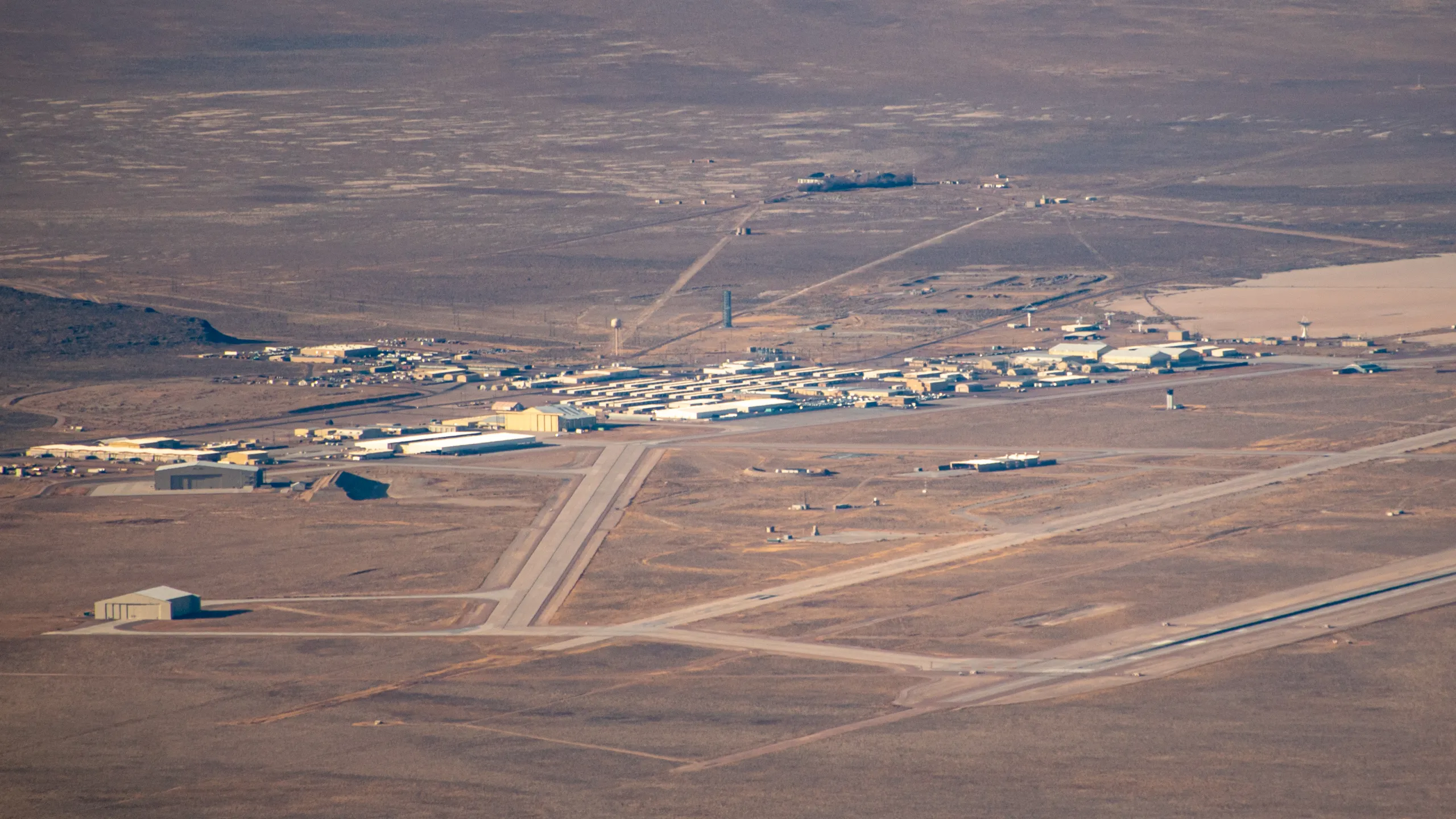
Across the vast, desolate expanses of the Nevada desert—punctuated by Joshua trees and barren dry lakebeds—lies a military installation that has captured the global imagination for generations: Area 51. Officially classified as a highly restricted United States Air Force facility, the site has become culturally synonymous with extraterrestrial recovery, reverse-engineered technology, and deep-seated government secrecy. What began as a covert Cold War proving ground for aerial reconnaissance platforms targeting the Soviet Union evolved into the world’s most famous focal point for rumors regarding non-human intelligence and off-world technology.

This comprehensive analysis examines the historical origins, declassified records, and enduring folklore surrounding Area 51. By evaluating official Central Intelligence Agency (CIA) documents alongside controversial whistleblower claims and contemporary political developments, this article separates verifiable aviation history from the persistent myths that continue to shroud Groom Lake.


Historical Background: Proving Ground for Reconnaissance Aircraft

Area 51 was established at the height of Cold War tensions in 1955. The Central Intelligence Agency selected the remote salt flat adjacent to Groom Lake, Nevada, as an isolated testing environment for the Lockheed U-2 high-altitude reconnaissance aircraft under Project AQUATONE. Designated on official government charts as “Area 51,” the extreme operational security surrounding the facility was designed specifically to shield military technology from Soviet satellite surveillance and signal intelligence.

Declassified CIA historical records confirm that the installation served primarily as an advanced flight-testing center for experimental military platforms rather than a storage facility for extraterrestrial artifacts. Following the U-2 program, the site hosted tests for the A-12 OXCART, the SR-71 Blackbird, and later stealth aircraft such as the F-117 Nighthawk.

High-Altitude Operations and the Surge in UFO Reports

The flight profiles of experimental reconnaissance platforms directly contributed to the emergence of regional UFO lore. During the mid-1950s, commercial airliners routinely operated at altitudes between 10,000 and 20,000 feet, while contemporary military fighters rarely exceeded 40,000 feet. The Lockheed U-2, operating at altitudes above 60,000 feet, flew in a regime previously considered impossible for manned aircraft.

At dusk and dawn, while lower altitudes descended into darkness, high-altitude U-2 aircraft catching the sun’s reflection on their bare aluminum wings appeared as brilliant, glowing objects to observers on the ground and commercial pilots below. Declassified CIA historical reports explicitly note that secret high-altitude reconnaissance flights accounted for more than half of all reported UFO sightings in the United States throughout the late 1950s and 1960s. Military officials routinely attributed these sightings to natural atmospheric phenomena or weather balloons to preserve the operational secrecy of the U-2 and subsequent stealth programs.


Catalysts for Extraterrestrial Mythology

The Roswell Incident of 1947

Although the recovery of metallic debris near Roswell, New Mexico, occurred eight years before Area 51 was established, popular culture tightly linked the two events. Initial press accounts citing the recovery of a “flying disc” were quickly clarified by military authorities as debris from a high-altitude weather balloon. Decades later, popular conspiracy theories asserted that recovered wreckage and biological materials were secretly transferred to Groom Lake for clandestine analysis. In 1994, an official U.S. Air Force inquiry confirmed that the Roswell material originated from Project Mogul—a top-secret initiative utilizing high-altitude balloon arrays to detect Soviet nuclear testing.

Bob Lazar’s Controversial Allegations

In 1989, public intrigue intensified dramatically when Bob Lazar claimed in media interviews that he had been employed as a reverse-engineering specialist at a sub-facility designated “S-4,” located near Groom Lake. Lazar alleged that the site housed nine captured extraterrestrial craft utilizing an anti-gravity propulsion system powered by a heavy element he identified as “Element 115.” The synthetic creation of Element 115 (later named Moscovium) by nuclear physicists in 2003 renewed public interest in Lazar’s accounts.

However, Lazar’s claims faced widespread skepticism due to significant discrepancies in his academic and professional records, including unverified claims of degrees from MIT and Caltech. While critics dismiss his story as fabrications or disinformation, supporters argue that official records were altered. Media projects, including the 2026 documentary “S4: The Bob Lazar Story,” demonstrate the continued cultural resonance of his narrative.


Covert Operations and Security Protocols at Groom Lake

Testing Advanced Stealth Platforms

Beyond high-altitude spy planes, Area 51 served as the primary development site for low-observable (stealth) aircraft. During testing for platforms like the F-117 Nighthawk and Tacit Blue, radar cross-section (RCS) evaluation required mounting prototype airframes atop high towers or specialized pylons. Observed from a distance, these unconventional shapes and testing rigs contributed to local reports of strange aerial structures.

Foreign Technology Evaluation

During the Cold War, United States defense agencies acquired various Soviet-built radar systems and fighter aircraft through covert procurement channels. These assets were transported to Area 51 for technical evaluation and mock combat exercises, allowing defense engineers to reverse-engineer foreign hardware and refine tactical countermeasures.

Deception Tactics and Strategic Camouflage

To counter Soviet orbital reconnaissance satellites, personnel at Area 51 utilized structured operational security measures, colloquially termed “Hide and Scoot” protocols. Personnel rapidly sheltered experimental aircraft inside hardened hangars prior to satellite overflights. Additionally, dummy airframes constructed from simple materials were positioned outdoors to cast deceptive heat and shadow signatures, confusing infrared orbital sensors.

Subterranean Infrastructure Rumors and Modern Observations

Persistent rumors contend that Area 51 features an extensive subterranean facility complex designed to conceal sensitive materials. While hardened underground command structures and secure storage bunkers are standard military engineering practices, claims of multi-level underground laboratories remain unverified. Modern satellite monitoring continues to attract attention; for instance, imagery analysis from early 2025 highlighting a tall, dark triangular structure inside the perimeter was identified by defense experts as a radar cross-section testing pylon rather than novel propulsion hardware.


Recent Political Discussions and Official Statements

In early 2026, public interest in government transparency regarding aerial phenomena resurfaced in mainstream political discourse. Statements by former political leaders regarding Unidentified Anomalous Phenomena (UAP) sparked renewed debates over executive declassification mandates and military records management.

Despite ongoing public interest, comprehensive historical reviews conducted by the Department of Defense—including formal findings published by the All-domain Anomaly Resolution Office (AARO)—maintain that exhaustive reviews of military records from World War II to the present have yielded no empirical evidence indicating off-world technology or non-human intelligence at government facilities.


Conclusion: The Intersection of Secrecy and Public Imagination

Area 51 represents a unique confluence of verified Cold War military history and modern pop culture mythology. Declassified records demonstrate that the facility was established, expanded, and maintained to serve as the nation’s premier testing ground for advanced reconnaissance and stealth aircraft, including the U-2, SR-71, and F-117.

The intense operational secrecy required to protect national security assets inadvertently created an information vacuum—one that was readily filled by UFO folklore, whistleblower claims, and speculative fiction. Ultimately, Area 51 remains an enduring symbol of how official silence and high-altitude technological innovation can give rise to world-famous legends.

What Lies Beneath Earth’s Deepest Oceans?

Introduction: The Hidden Realm of the Hadal Zone

When imagining the depths of the world’s oceans, human perception often halts around 200 meters below the surface—the limit where solar light fades entirely into the bathypelagic twilight. Yet, the absolute deepest oceanic frontiers—designated as the Hadal Zone—extend from 6,000 meters down to nearly 11,000 meters into subsea trenches. This is an environment defined by catastrophic hydrostatic pressures capable of crushing unreinforced steel, complete solar absence, and near-freezing temperatures. Despite these extreme conditions, advanced deep-sea research confirms that these remote abyssal depths harbor thriving, complex biological communities.

Recent deep-sea expeditions and genomic analyses have fundamentally transformed our scientific understanding of hadal biology. The discovery of novel invertebrate species, specialized chemosynthetic ecosystems, and high-pressure genomic adaptations demonstrates that extreme oceanic trenches are not desolate marine deserts, but rather dynamic cradles of specialized biodiversity.


Defining the Hadal Zone: Environmental Extremes

Etymologically named after Hades—the ancient Greek god of the underworld—the Hadal Zone comprises a series of deep-sea V-shaped topographic trenches formed by tectonic subduction, where one oceanic plate plunges beneath another. The deepest surveyed point on Earth, the Challenger Deep within the Mariana Trench, descends to approximately 10,900 meters below sea level.

Hydrostatic pressure at these depths exceeds 1,000 atmospheres (atm)—more than 800 times the ambient atmospheric pressure felt at sea level. Despite these crushing physical mechanics, biological life has evolved highly specialized cellular and biochemical adaptations to flourish under extreme pressure.


Novel Marine Life Discovered in Hadal Trenches

The deployment of advanced deep-submergence vehicles, such as China’s Fendouzhe (Striver) manned submersible capable of repeatedly reaching 11,000-meter depths, has enabled marine biologists to observe, photograph, and collect biological specimens directly from trench ecosystems.

Hard-Substrate Endemic Fauna: “Stone Feather” Communities

Scientific surveys have revealed unexpected hard-substrate benthic ecosystems on rocky trench walls. Dense colonies of microscopic organisms—reaching densities up to 4,300 individuals per square decimeter—have been documented attached to rocky outcrops at extreme depths.

Among these are newly classified foraminifera and bryozoan species discovered below 9,900 meters. These microscopic benthic organisms form specialized encrusting colonies, establishing the deepest known hard-substrate invertebrate communities recorded in marine biology.

Chemosynthetic Ecosystems Beyond Sunlight

Another monumental discovery in hadal research is the identification of ultra-deep chemosynthetic communities operating completely independent of solar energy. Researchers have documented thriving benthic habitats below 9,500 meters powered by chemical cold seeps.

Specialized organisms—including specialized tubeworms and bivalves—rely on chemosynthetic bacteria that metabolize methane and hydrogen sulfide escaping from active subduction zones beneath the seabed. This confirms that complex chemosynthetic ecosystems extend into the deepest reaches of the ocean floor.

Deep-Sea Predatory Crustaceans

In the Atacama Trench off the coast of South America, researchers operating at depths approaching 8,000 meters identified a novel predatory amphipod species designated Dulcibella camanchaca. Measuring four centimeters in length, this blind crustacean uses specialized raptorial appendages to hunt smaller benthic fauna, representing both a newly discovered species and a distinct genus adapted to high-pressure predatory niches.


Genomic Insights and Evolutionary Adaptation

Modern genomic sequencing has unlocked the biochemical secrets allowing hadal fauna to survive extreme hydrostatic stress. A research team from the Chinese Academy of Sciences successfully sequenced the complete genome of Hirondellea gigas, an amphipod crustacean native to the Mariana Trench floor.

Spanning 13.92 gigabases, this genome represents the largest animal genome sequenced from the deep sea to date. The analysis revealed a 72% concentration of repetitive genetic elements, which play a crucial role in gene regulation, protein stabilization, and cellular repair under severe physical compression.

Vertical Migration and Population Dynamics

Genomic profiling across 510 individual Hirondellea gigas specimens revealed that these amphipods exhibit vertical migration ranges extending between 7,000 and 11,000 meters. This demonstrates remarkable physiological tolerance across a wide hydrostatic pressure gradient.

However, comparative genetic studies between geographically separated trenches show significant genetic divergence. While vertical movement within a single trench is common, horizontal dispersal between isolated oceanic trenches remains severely restricted by topographically high abyssal plains.

Evolutionary Lineages of Hadal Fishes

Comparative genomic analyses of hadal fish species, such as snailfish (Liparidae), reveal two distinct evolutionary trajectories into the deep trenches:

  • Ancient Lineages: Primitive deep-sea taxa that transitioned into abyssal environments over 100 million years ago, potentially seeking thermal refuge from surface extinction events like the Cretaceous-Paleogene impact.
  • Recent Colonizers: Secondary radiation events where shallow-water teleost families adapted to hadal trench environments within the last 20 million years, developing specialized metabolic pathways and TMAO (trimethylamine N-oxide) protein stabilizers to prevent cell membrane collapse.

Deep Physical Oceanography: Trench Water Mixing

Hadal research also addresses physical oceanographic processes. Hydrodynamic modeling within the Challenger Deep indicates that internal tidal forces generated along trench walls drive intense localized vertical water mixing (exceeding 10⁻³ m²/s).

This vigorous vertical circulation transports dissolved oxygen and organic particulate matter down into the deepest subduction zones, providing vital nutritional input for microbial and benthic ecosystems on the trench floor.


Anthropogenic Impacts on Hadal Ecosystems

Despite their extreme remoteness, hadal trenches are not insulated from human activity. High-definition imaging from deep-submergence dives has documented synthetic debris—including plastic bags, aluminum cans, and industrial waste—resting at depths exceeding 10,000 meters.

Furthermore, chemical bioaccumulation analyses of deep-sea amphipods reveal significant concentrations of persistent organic pollutants (POPs), microplastics, and heavy metals. This underscores how surface pollution eventually sinks into the planet’s deepest marine sanctuaries.


Conclusion

The Hadal Zone represents one of the final biological frontiers on Earth. Discoveries of novel chemosynthetic habitats, unique crustacean species, and extreme genomic adaptations confirm that life possesses an extraordinary capacity to adapt to the most inhospitable environments on the planet.

As autonomous submersibles, deep-sea genomic tools, and non-invasive observational technologies continue to advance, scientists will unlock further secrets buried within these subsea trenches. The Hadal Zone serves as a powerful reminder of how much remains to be discovered within our world’s oceans.

The Lost City of Atlantis: Myth or History?

Introduction: A Legend Preserved for Two Millennia

In his seminal Socratic dialogues Timaeus and Critias, the classical Greek philosopher Plato first introduced the world to an island power he designated as Atlantis. According to his written accounts, this advanced and formidable empire existed approximately 9,000 years prior to his own era (roughly 11,600 years before the present day). Plato described Atlantis as a dominant thalassocracy that commanded vast naval routes, governed extensive territories, and projected unmatched geopolitical force across the known Mediterranean world. However, as the narrative unfolds, a catastrophic sequence of earthquakes and deluges submerged the entire landmass into the depths of the Atlantic Ocean in a single day and night of ruin, erasing its physical presence from human geography.
For more than two and a half millennia, Plato’s account has stood as one of the most enduring intellectual enigmas in world history. Was the chronicle of Atlantis merely an allegorical parable designed to illustrate philosophical principles regarding civic virtue and hubris? Or does it retain an underlying core of genuine Bronze Age historical reality, distorted over centuries of oral transmission? This comprehensive investigation explores the primary textual narrative, evaluates candidate geographic locations using modern scientific methodologies, and assesses how contemporary underwater archaeology, geology, and historical analysis approach this legendary lost empire.


The Platonic Account: Textual Foundation and Narrative Structure

Plato (c. 427–347 BCE) formally detailed the legend of Atlantis across two interconnected philosophical works: the Timaeus and the uncompleted Critias. Within these texts, Plato constructs a framing mechanism attributing the story to his ancestor Solon, the revered Athenian lawmaker. Solon reportedly acquired the historical account during his travels to Egypt in the early 6th century BCE, specifically from the sacerdotal records preserved by Egyptian priests in the city of Sais who maintained written archives stretching back thousands of years.

According to the detailed descriptions in Critias, the capital city of Atlantis was an architectural marvel constructed from quarried stones of red, white, and black hues. The metropolis was engineered in a series of perfectly concentric rings of alternating land and water channels, interconnected by wide, subterranean canal networks that allowed naval vessels to navigate directly to the inner citadel. At the center of this ringed city sat a fortified hill hosting a grand temple dedicated to Poseidon, the patron deity of the island. The temple was clad in precious metals, including silver, gold, and a glowing metallic alloy known as orichalcum. The imperial dockyards were vast, capable of housing and outfitting a fleet of 1,200 warships alongside an extensive commercial merchant marine.

At its geopolitical zenith, the Atlantean empire expanded its dominion across vast regions, subjugating parts of Western Europe and North Africa as far as Libya and Tyrrhenia. However, as generations passed, the divine lineage of the Atlantean ruling class became diluted by human frailty. The civilization degenerated into materialism, imperial aggression, and tyrannical arrogance. In response to their moral decay, the divine council decreed severe retribution: “In a single day and night of misfortune, violent earthquakes and floods engulfed the island, and Atlantis sank beneath the sea, leaving behind an impassable barrier of shallow mud.”


Geographic Candidates: Evaluating Proposed Locations

Plato explicitly situated Atlantis “beyond the Pillars of Hercules,” referencing the Strait of Gibraltar that marks the boundary between the Mediterranean Sea and the open Atlantic Ocean. This geographic marker has inspired hundreds of hypotheses over the centuries, placing the lost civilization in locations spanning the globe. Below is a rigorous analysis of key candidate sites proposed by researchers and historians.

1. The Siberian Freshwater Basin Hypothesis

In 2023, researcher Geo Wang proposed a controversial hypothesis suggesting that Atlantis was originally located in Siberia near an ancient, high-altitude freshwater lake system rather than a traditional ocean basin. This perspective reinterprets classical translations, arguing that terms translated as “ocean” or “sea” in Platonic Greek could originally refer to vast inland water bodies or impassable marshlands. Proponents of this view cite local ecological indicators, including ancient freshwater marine life adaptations (such as isolated freshwater shark species in Asian lake systems), as potential evidence of dramatic landlocked hydrological shifts.

Despite its novel approach, the Siberian hypothesis remains highly speculative within the academic community. It relies on non-standard linguistic re-interpretations of classical Greek texts and lacks supporting archaeological artifacts, structural remains, or geological evidence demonstrating a sophisticated Bronze Age urban civilization in prehistoric Siberia.

2. The Sardinian Nuragic Civilizational Hypothesis

In 2024, cultural heritage specialists and archaeologists focusing on the Western Mediterranean proposed that the Atlantis myth was heavily inspired by the prehistoric Nuragic civilization of Sardinia or an allied Western Mediterranean maritime culture.

Proponents point out that Sardinia was home to a sophisticated, highly organized megalithic society that constructed over 8,000 monumental stone towers (nuraghi) alongside complex sacred well-temples and fortified villages during the Bronze Age. According to this theory, ancient Egyptian or early Mycenaean traders encountered this powerful, megalithic maritime culture, and its impressive engineering feats were gradually mythologized and exaggerated through centuries of oral storytelling.

Furthermore, researchers investigating submerged coastal structures point to natural geological formations and prehistoric submerged land bridges near Sardinia and the Strait of Sicily (comparable in popular speculation to the submerged stone pavements of the Bimini Road in the Bahamas). These submerged coastal features demonstrate that rising post-glacial sea levels inundated significant coastal settlements across the Mediterranean basin, providing a historical basis for catastrophic flooding myths.

3. The Minoan Civilization and the Thera Eruption

The Minoan Hypothesis represents the most scientifically robust and widely accepted historical explanation among mainstream classicists and archaeologists. This theory posits that the Atlantis narrative is a historical memory of the advanced Minoan civilization centered on Crete, which was devastated by the catastrophic cataclysm of the Thera (Santorini) volcanic eruption around 1600 BCE.

The evidence supporting this hypothesis is extensive and structurally sound:

  • Architectural and Cultural Parallels: The Minoans possessed a sophisticated, highly prosperous maritime trading empire with extensive commercial networks linking Greece, Egypt, and the Levant. Minoan palaces—such as Knossos—featured advanced multi-story architecture, complex indoor plumbing, sophisticated drainage systems, and vibrant multi-colored frescoes that closely match Plato’s descriptions of Atlantean wealth.
  • The Thera Cataclysm: The eruption of the Thera volcano was one of the most violent explosive volcanic events in human history (VEI 7). The eruption generated massive regional tsunamis exceeding 100 feet in height, blanketed the Eastern Mediterranean in toxic ash, collapsed coastal ports, disrupted agricultural cycles, and critically weakened Minoan maritime supremacy, paving the way for Mycenaean conquest.
  • Chronological and Numerical Calibration: Historical linguists note that if the Egyptian numerical symbol for “hundreds” was mistranslated as “thousands” during oral transmission or transcription, Plato’s timeline of 9,000 years before Solon shifts to precisely 900 years before Solon. This adjustment aligns the destruction of Atlantis directly with the collapse of Minoan maritime power following the Thera eruption around 1600 BCE.

Because this model relies strictly on verified archaeological remains, geological core samples, and established historical events without invoking supernatural phenomena, it remains the leading scientific candidate for the origin of the legend.

4. Lost Civilizations in the Red Sea Basin

Alternative theories have occasionally proposed candidate sites along the Red Sea coast, arguing that ancient trade routes between Egypt, the Arabian Peninsula, and the Horn of Africa host submerged prehistoric coastal settlements. Proponents suggest that tectonic activity along the Red Sea Rift led to localized coastal submergence events that fed into regional folklore.

However, this hypothesis directly contradicts Plato’s explicit geographical placing of Atlantis outside the Pillars of Hercules (the Strait of Gibraltar) and lacks empirical archaeological support linking submerged Red Sea features to an advanced urban empire matching the Platonic description.


Archaeological Challenges and Modern Survey Methodologies

Despite centuries of intensive exploration, no definitive physical evidence or archaeological site has been conclusively identified as the lost city of Atlantis. Modern marine archaeology approaches the search through rigorous scientific constraints:

  • Absence of Primary Cartographic or Structural Blueprints: Plato’s accounts provide vivid philosophical descriptions but lack precise cartographic coordinates or verifiable engineering schematics, leaving room for endless geographic speculation.
  • Limitations of Bathymetric and Oceanographic Surveying: While satellite altimetry and high-resolution multibeam sonar have mapped the global ocean floor at macro-scales, vast areas of the deep seabed remain unexamined at the fine resolutions required to detect submerged urban ruins buried beneath millennia of marine sediment and coral growth.

Philosophical, Allegorical, and Moral Dimensions

A majority of classical scholars and historians argue that Atlantis was never intended to be understood as a literal historical city. Rather, Plato constructed Atlantis as an allegorical moral fable—a philosophical thought experiment designed to contrast his ideal, virtuous state (represented by ancient prehistoric Athens in the dialogue) against a wealthy, hubristic empire that corrupted its own ideals through imperial overreach.

This moral warning was acutely relevant to 4th-century BCE Athens. Plato was writing in the aftermath of the Peloponnesian War, a devastating conflict in which the Athenian maritime empire, driven by imperial ambition and arrogance, suffered a humiliating defeat against Sparta. By depicting the total annihilation of Atlantis, Plato delivered a stark warning to his contemporaries regarding the inevitable fate of any society that prioritizes wealth, military conquest, and material power over moral integrity and civic virtue.


Conclusion: The Legacy of Atlantis

The mystery of Atlantis has captivated the human imagination for over two thousand years. While no submerged megalithic city matching Plato’s exact concentric layout has ever been discovered, scientific consensus strongly leans toward the view that the legend was inspired by real Bronze Age cataclysms—most notably the catastrophic decline of the Minoan civilization following the Thera eruption, augmented by Plato’s philosophical framework.

Unless future deep-sea archaeological surveys uncover indisputable structural and epigraphic evidence of a vast ringed city lying beneath marine sediment, Atlantis will remain a powerful cultural myth and philosophical allegory.

Ultimately, the core message of Atlantis remains timeless: societies that succumb to arrogance, unchecked greed, and environmental negligence risk their own collapse. Whether viewed as an actual historical tragedy or a brilliant philosophical parable, the story of Atlantis continues to invite reflection on the fragile nature of human civilization.

Voyage of the Titanic: Hidden Historical Secrets

Introduction

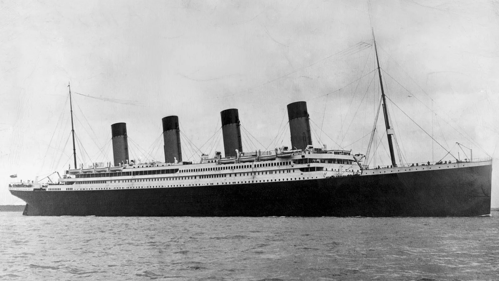
The sinking of the RMS Titanic on April 14, 1812, remains a historical event that fundamentally challenged human hubris and technological overconfidence. Proclaimed to be “unsinkable,” the flagship vessel struck an iceberg on its maiden voyage across the North Atlantic, descending to the ocean floor and claiming more than 1,500 lives. For many, the official narrative—a high-speed collision with an iceberg combined with a shortage of lifeboats—appears insufficient to fully account for the scale of the tragedy, giving rise to persistent alternative theories and claims of hidden motives.
This article examines the lesser-known hypotheses and documented technical factors surrounding the disaster, including insurance fraud claims, structural vulnerabilities, crew decision-making, and modern forensic discoveries.


Conspiracy 1: Was the Ship Swapped? The “Olympic Conspiracy” Case

Among the most enduring theories regarding the Titanic is the assertion that the vessel that sank was not the Titanic, but its sister ship, the RMS Olympic. Proponents of this claim argue that the parent company, White Star Line, orchestrated an identity swap as part of an insurance fraud scheme.

Background of the Claim: In September 1911, the RMS Olympic suffered significant structural damage following a collision with the British warship HMS Hawke. Because the White Star Line was found liable for the incident, insurance coverage was denied, leaving the company with substantial repair costs. Theorists suggest that company executives executed a covert plan: perform superficial repairs on the damaged Olympic, rebrand it as the Titanic, and deliberately sink it during a staged maritime accident to collect the insurance policy payout.

Historical Refutation: Maritime historians and forensic researchers universally reject the ship-swap theory based on several key facts:

  • Financial Infeasibility: Deliberately scuttling a brand-new ocean liner for an insurance claim represents a highly illogical business decision. The repair costs for the Olympic—which was successfully restored and operated for decades—were far lower than the financial loss of scuttling a flagship vessel. White Star Line maintained strong financial backing, making such a scheme commercially irrational.
  • Architectural and Design Differences: Completely swapping the identities of the two vessels was structurally impossible. The ships featured distinct design variations, interior layouts, and window configurations (port holes). Altering these features alongside underwater propulsion systems covertly would have required an unfeasible logistical effort.
  • Physical Evidence: High-resolution 3D digital scans of the wreckage resting on the ocean floor confirm that the structural serial numbers stamped into the hull components and internal machinery match those of the Titanic, not the Olympic.

Conspiracy 2: The “J.P. Morgan Scheme” and the Federal Reserve Myth

Another popular theory centers on American financier J.P. Morgan, whose conglomerate, the International Mercantile Marine, owned the White Star Line. Morgan had initially booked passage on the Titanic’s maiden voyage but canceled his reservation shortly before departure.

The Theory: Proponents claim Morgan orchestrated the sinking to eliminate three prominent American millionaires onboard—Jacob Astor, Isidor Straus, and Benjamin Guggenheim. The premise suggests these individuals opposed the creation of the United States Federal Reserve central banking system, and Morgan sought their removal to advance his financial interests.

Historical Reality: Historians dismiss this assertion due to a lack of factual evidence. Historical records show that Isidor Straus actually supported the creation of a centralized banking system, while Astor and Guggenheim took no active public stance on the matter. Furthermore, Morgan possessed immense political and financial leverage, making a dangerous maritime sabotage plot entirely unnecessary to achieve his business objectives.


Documented Technical Vulnerabilities: The Coal Fire and Hull Integrity

Beyond speculative conspiracy claims, a documented operational factor contributed to the structural vulnerability of the ship: an unextinguished coal bunker fire.

Historical Context: A spontaneous combustion fire broke out in one of the Titanic’s coal bunkers ten days prior to departure and continued to burn throughout the transatlantic passage. Coal fires were relatively common on steam-powered ocean liners of that era.

Impact on Structural Integrity: Investigative journalist Senan Molony posits that the sustained heat from the bunker fire compromised the structural integrity of the steel hull. Analyzing historical photographs from 1912, Molony identified a dark mark along the starboard side of the hull near the location where the iceberg later struck. He argues that prolonged exposure to extreme heat weakened the steel plating, making the hull significantly more susceptible to breach upon impact.

Counterarguments: Marine engineering experts, including author Samuel Halpern, dispute the claim that the coal fire critically compromised the ship’s watertight bulkheads. Other analysts note that coal management efforts to isolate the fire required transferring coal to the opposite side of the ship, creating a slight port list that may have actually helped stabilize the vessel and delay capsize following the collision.


Findings from the 3D Digital Scan

Investigative research into the disaster advanced significantly with the release of the first complete 3D digital scan (“Digital Twin”) of the Titanic wreck, situated 3,800 meters below the surface of the North Atlantic. Constructed from over 700,000 high-resolution photogrammetric images, the scan provides unprecedented clarity regarding the state of the wreck.

Key findings from the digital mapping include:

  • Engineering Sacrifices: Scans revealed a disengaged steam valve mechanism, providing physical evidence that the engineering crew remained at their posts deep within the ship to maintain electrical power as the vessel sank. All 35 engineers and boiler room crew sacrificed their lives to keep lights and communication systems operational, facilitating the evacuation.
  • Officer Duty Confirmations: Historical accounts regarding First Officer William Murdoch were clarified; the position of the davit mechanisms (lifeboat deployment cranes) indicates that officers worked to lower lifeboats until the final moments before the deck submerged.
  • Structural Breakup Dynamics: The mapping data confirmed that the vessel underwent severe structural failure as it broke apart, scattering debris across a vast field on the ocean floor rather than sinking intact.

Third-Class Passengers and Evacuation Realities

Beyond technical factors, historical analysis continues to evaluate the conditions faced by third-class (steerage) passengers during the evacuation.

Historical inquiries document that steerage passengers faced significantly higher casualty rates. Contributing factors included the complex internal layout of the lower decks, language barriers among international travelers, and limited access pathways leading up to the boat deck. While some historical accounts suggest crew members restricted access from the lower decks during the early stages of the emergency, researchers emphasize that general confusion and delayed warnings contributed heavily to the loss of life among third-class passengers.


Conclusion

The Titanic disaster remains a complex intersection of human error, technical limitations, and historical circumstance. While modern 3D scanning and forensic analysis continue to clarify the physical mechanisms of the sinking, popular interest in conspiracy claims persists.

Ultimately, the documented evidence confirms that the disaster was the result of a catastrophic collision compounded by environmental conditions and structural vulnerabilities, rather than a coordinated plot. The legacy of the Titanic continues to offer valuable lessons in maritime safety, engineering design, and emergency preparedness.

Wow! Signal: Unexplained Alien Radio Message

Introduction: An Extraordinary Discovery

Around midnight on August 15, 1977, the Big Ear radio telescope at Ohio State University recorded a powerful radio signal originating from deep space. The signal exhibited characteristics so unique that days later, while reviewing the printed data, astronomer Jerry R. Ehman circled the anomaly in red ink and wrote a single exclamation in the margin: “Wow!” Thus, one of radio astronomy’s most famous mysteries received its name.

The signal lasted for 72 seconds—the exact duration Big Ear was capable of observing a single point in the sky as Earth rotated—and was never detected again. For nearly half a century, it has remained an enduring mystery in observational astronomy, shaping the Search for Extraterrestrial Intelligence (SETI).


Signal Characteristics: Why Was It Unique?

The Wow! Signal displayed specific properties that matched theoretical signatures expected from intentional artificial radio transmissions:

  • Narrow Bandwidth: The signal possessed a bandwidth under 10 kHz. Broadband emission is typical of natural astronomical sources, whereas extreme narrowband signals are characteristic of artificial origin or technosignatures.
  • Proximity to the Hydrogen Line (1420 MHz): The transmission was recorded at approximately 1420.455 MHz, adjacent to the neutral hydrogen line. Because hydrogen is the most abundant element in the universe, astrophysicists had long hypothesized that interstellar communications might utilize this frequency band as a universal standard.
  • Signal Intensity: The transmission peaked at 30 times the level of background cosmic noise. On the alphanumeric printout, its intensity progression was encoded as 6EQUJ5, where the character ‘U’ represented a signal-to-noise ratio between 30.0 and 30.999—the highest intensity ever recorded by Big Ear.
  • Observation Pattern: The signal’s intensity rose and fell over 72 seconds, mirroring the exact spatial response pattern expected of a fixed celestial source passing through Big Ear’s stationary antenna feed.

Origin Hypotheses and Scientific Investigations

The Cometary Hypothesis

In 2015, a hypothesis suggested that hydrogen gas clouds surrounding two comets (266P/Christensen and P/2008 Y2 Gibbs) might have generated the signal.

However, this explanation was evaluated and largely dismissed by former Big Ear director Robert Dixon and Jerry Ehman due to several observational conflicts:

  • Positional Discrepancy: Ephemeris calculations indicated the comets were not situated within Big Ear’s observational beam at the time of detection in 1977.
  • Dual-Feed System Discrepancy: Big Ear utilized two feed horns scanning the same declination separated by 3 minutes and 20 seconds (70 seconds in observation time). The Wow! Signal appeared in only one feed. A diffuse or slow-moving cometary source should have registered in both feeds.
  • Flux Density: Hydrogen emissions from comets do not produce the high flux density recorded during the event.

The Interstellar Object Hypothesis

In 2025, a proposal raised the possibility that the signal was associated with the interstellar object 3I/ATLAS, located roughly 600 AU from Earth.

This proposal faced significant constraints:

  • Transmitting a signal of that magnitude across hundreds of Astronomical Units would require power levels far exceeding conventional passive emission.
  • The celestial coordinates of the object differed significantly from the primary beam pointing of the telescope during the 1977 recording.

Natural Astronomical Sources: Magnetar-Stimulated Emission

A prominent current model attributes the signal to a rare natural astrophysical event. Research led by astronomer Abel Méndez under the Arecibo Wow! Project offers a mechanism explaining the observation.

Studies published in 2024 suggest the signal resulted from an intense astrophysical outburst stimulating a cold hydrogen cloud:

  1. Cold Hydrogen Reservoir: Background clouds of neutral hydrogen naturally emit weak 1420 MHz radio waves.
  2. Transient Energetic Event: A highly magnetized neutron star (a magnetar) undergoes a sudden flare event.
  3. Maser Amplification: The intense, focused radiation beam passes through the intervening hydrogen cloud, acting as a natural microwave amplifier (maser) and multiplying the 1420 MHz emission intensity along the line of sight.
  4. Observed Result: A brief, high-intensity, narrowband radio emission is produced that matches the observed profile of the Wow! Signal.

This model accounts for the non-repeating nature of the event, as the precise alignment required between the transient flare, interstellar cloud, and terrestrial receiver would be exceptionally rare.

Data Digitization Insights

In 2025, efforts to digitize 75,000 pages of original Big Ear archival printouts enabled high-resolution computational re-analysis of the raw data logs.

This re-analysis indicated that the peak signal flux density was higher than initially calculated, while confirming its frequency alignment near 1420 MHz. The data verified that the detection was an authentic celestial signal rather than terrestrial radio frequency interference (RFI) or an internal instrumentation error.


Conclusion

The Wow! Signal remains one of radio astronomy’s most studied phenomena. While natural emission models—such as magnetar-induced maser amplification—provide plausible mechanisms, the lack of follow-up detections prevents a definitive conclusion.

As astronomer Seth Shostak of the SETI Institute noted, in empirical science, a non-repeatable observation cannot be conclusively verified.

Whether the Wow! Signal represents an unprecedented astrophysical event or a brief technosignature, it remains a landmark milestone in the search for signals from the cosmos.